









ORLANDO, Fla. – Central Florida residents hoping for a reprieve from the relentless summer heat and moisture will have to keep their umbrellas close at hand, as meteorologists warn of a soaking, multi-day weather pattern taking hold across the region.
The immediate forecast calls for active weather beginning Friday. Forecasters at the National Weather Service expect scattered to numerous showers and thunderstorms to develop between noon and Friday night. While the daily storm cycle is common for the region, this particular setup carries a heightened risk of intensity.
Residents should prepare for potential strong storms capable of producing frequent lightning, wind gusts ranging from 35 to 45 mph, and torrential rainfall. Weather experts are particularly concerned about high precipitation rates, noting that some localized areas could see 2 to 4 inches of rain in just a single hour. Such intense bursts threaten to trigger minor flooding in low-lying areas and could create hazardous conditions on roadways during the Friday evening commute.
Beyond the rain, the atmospheric conditions remain stifling. High temperatures are expected to reach the upper 80s to low 90s, but with extreme humidity, heat indices will soar to between 100 and 105 degrees.
The unsettled weather will bleed into the weekend as a weak front remains stalled to the north of the peninsula. Saturday and Sunday will follow a familiar pattern: hot, humid mornings followed by afternoon storms. The most active weather is expected during the prime afternoon and early evening hours, specifically between 2 p.m. and 7 p.m. Heat indices will continue to hover in the triple digits throughout the weekend, necessitating caution for those spending time outdoors.
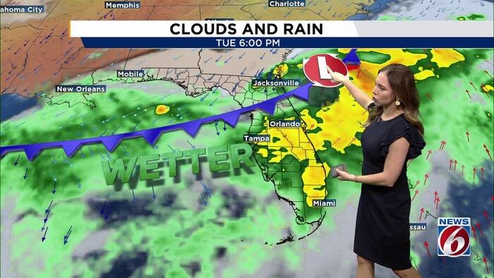
However, the most significant meteorological shift is slated for early next week. A cold front is expected to push into Central Florida by Monday, where it is currently forecast to stall through the middle of the work week. This boundary will serve as a focus for consistent, heavy rainfall, with projections indicating a 70% to 90% chance of rain each day from Monday through Thursday.
“With slow-moving and potentially training storms, heavy rainfall and flooding could become the biggest concern next week,” warned the News 6 Weather team, noting that the threat will be most acute in areas prone to drainage issues.
While the increased rain may bring some relief from the persistent heat, temperatures remain largely dependent on the exact position of the front. If the boundary pushes far enough south, some cooler, more comfortable air may infiltrate the region by Tuesday and Wednesday. Until then, officials advise residents to monitor local updates closely and exercise caution while navigating flooded roadways or participating in outdoor activities.
Copyright 2026 by WKMG ClickOrlando – All rights reserved.
Disclaimer: This content is auto-generated for informational purposes only.
Source: Read Original News