






GULF OF MEXICO — Meteorologists are closely monitoring the southwestern Gulf of Mexico after satellite imagery confirmed the formation of Tropical Depression Nine, the ninth named system of the 2026 Atlantic hurricane season.
The system, which had been under observation as an area of low pressure, has successfully developed a closed circulation center, a key indicator of organized tropical activity. According to the latest data, the depression’s associated showers and thunderstorms have significantly increased in organization, prompting authorities to designate it as a tropical depression.
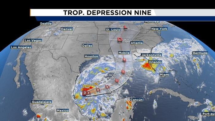
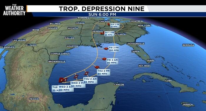
As of the latest advisory, the center of the storm is located near latitude 22.1 North and longitude 95.6 West. Currently, the system is moving at a slow pace toward the east at approximately 5 mph. This slow eastward drift is expected to persist over the next 48 hours, followed by a pivot. Forecasters anticipate the depression will maintain an east to east-northeasterly track before taking a more definitive turn toward the northeast by Friday.
Based on current projected paths, the system is expected to pass north of the Yucatan Peninsula on Thursday. From there, it is forecast to track toward the northern Gulf Coast of the United States, bringing potential impacts to the region by the end of the week.
Environmental conditions appear primed for rapid development. Currently, the depression is packing maximum sustained winds near 35 mph with even higher gusts, and the central pressure is estimated at 1007 millibars (29.74 inches). Experts expect steady strengthening as the system moves over warm Gulf waters. Meteorologists are forecasting that the depression will intensify into a tropical storm by early Wednesday, with further development expected to reach hurricane status by Thursday.
Residents across the northern Gulf Coast are being urged to stay alert and monitor local forecasts as the system’s track and intensity continue to evolve. Emergency management officials are keeping a close watch on the storm’s trajectory to determine if protective measures or evacuation protocols will be necessary in the coming days.
While the storm is still in its developing stages, the transition from a disorganized area of low pressure to a defined depression marks a significant shift in the weather pattern for the region. Weather authorities emphasize that the transition to a hurricane, if realized, will drastically change the scope of the threat posed to coastal communities.
Further updates will be issued as new satellite imagery and reconnaissance data become available. Residents in the projected path are advised to review their hurricane preparedness plans and remain updated on official warnings issued by their local National Weather Service offices.
Copyright 2026 by WJXT News4JAX – All rights reserved.
Disclaimer: This content is auto-generated for informational purposes only.
Source: Read Original News