









MIAMI — The National Hurricane Center (NHC) is maintaining a watchful eye on the Atlantic basin this Thursday morning as meteorologists track the continued progression of Subtropical Storm Josephine and evaluate a new area of unsettled weather developing off the coast of Bermuda.
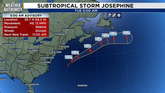
As of the latest advisory from the NHC, Subtropical Storm Josephine is currently located in the open Atlantic, maintaining maximum sustained winds of 65 mph. The storm is tracking toward the northeast at approximately 13 mph. Forecasters have confirmed that Josephine is moving steadily away from the United States coastline, posing no immediate threat to the mainland.
While the storm is currently classified as a subtropical system, experts expect it to undergo a transition into a powerful extratropical cyclone within the next 24 hours. This shift in structure could lead to a significant increase in intensity, with models suggesting the system may reach hurricane-force winds by early Friday. Despite this potential for increased strength, its projected path continues to carry it further into the northern Atlantic, keeping it far removed from any populated landmasses.
Simultaneously, the NHC is monitoring a separate area of interest located several hundred miles east-southeast of Bermuda. This disturbance, currently manifesting as a broad trough of low pressure, is producing disorganized showers and thunderstorms.
According to the latest meteorological outlook, the system has a 10% chance of developing into a more organized tropical or subtropical system over both the next 48 hours and the coming week. Forecasters remain optimistic that the system will struggle to gain traction; increasingly unfavorable upper-level winds are expected to shear the area of low pressure, likely inhibiting any significant development as the system moves into the latter half of the week.
Even with the low probability of development, hurricane experts stress that the Atlantic remains a dynamic environment. Weather patterns can shift rapidly, and authorities advise residents in coastal regions and those with interests in Atlantic shipping lanes to remain vigilant.
“While Josephine is moving safely away and the second system currently shows little promise for organization, it is a reminder that we are in the heart of an active season,” said one meteorologist. “Conditions can change, and it is vital for the public to continue monitoring official updates from the National Hurricane Center.”
For now, the focus remains on Josephine’s transition into an extratropical cyclone. Officials will continue to provide regular updates as new satellite data becomes available, ensuring that the public remains informed on both the strengthening storm and the weakening disturbance in the eastern Atlantic.
Copyright 2026 by WJXT News4JAX – All rights reserved.
Disclaimer: This content is auto-generated for informational purposes only.
Source: Read Original News