




JACKSONVILLE, Fla. – Residents across the Jacksonville area are being urged to remain vigilant this weekend as a combination of breezy conditions, an approaching weather front, and persistent coastal flood alerts threaten to impact daily routines.
Meteorologists report that the region will continue to experience partly to mostly cloudy skies through the remainder of the day. The atmosphere remains active, with a northeasterly wind flow expected to create breezy conditions, featuring gusts that could reach up to 30 mph at times. These winds are also contributing to the formation of isolated showers, particularly for those living in immediate coastal areas.
Of primary concern to local officials is the ongoing threat of coastal flooding. Alerts remain in effect through early next week, and residents are advised to stay alert for rising water levels, especially during high tide cycles. Caution is urged for motorists traveling near the coast, as even minor flooding can create hazardous road conditions.
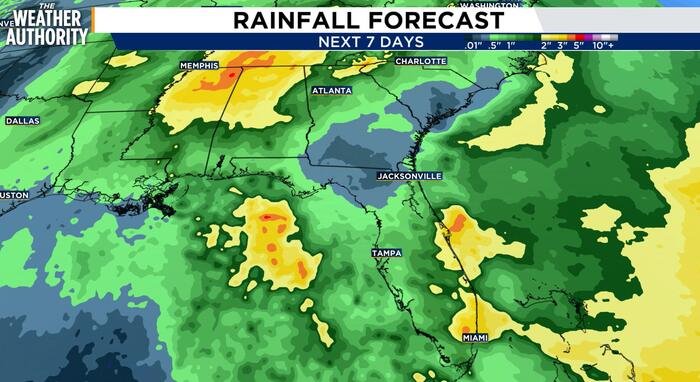
The weather pattern is expected to shift slightly on Sunday as a disturbance moves into the region. This system will bring a thicker blanket of clouds, alongside the potential for scattered showers and storms. While the day will remain warm with high temperatures reaching into the 70s, the rainfall could become heavy at times, stretching from Sunday through Monday afternoon.
Current forecasts suggest that while the most significant rainfall totals are expected to remain to the south of the Jacksonville area, any localized intensity could lead to isolated instances of flooding, particularly in low-lying areas already saturated from recent events.
The start of the work week will see little change in the overall theme. Monday and Tuesday will remain warm and humid with highs hovering near 80 degrees, accompanied by continued breezy conditions and the persistent risk of scattered showers. Looking further ahead, weather models indicate a cold front is likely to approach the region by mid-to-late week, which will provide a significant uptick in rain and storm coverage by Wednesday and Thursday.
Despite the immediate concern regarding potential flooding, the recent unsettled weather has brought some positive news for the region’s long-term environmental health. The latest drought monitor shows significant improvement across Northeast Florida. Substantial rainfall over the past week has been enough to pull several areas out of drought classification, marking a welcome shift in the region’s moisture levels.
Residents are encouraged to monitor local weather updates closely throughout the week, especially regarding the status of coastal flood alerts and the arrival of the midweek front.
Weekly Outlook:
- Tonight: Partly to mostly cloudy, breezy, with isolated coastal rain. Low: 67°F.
- Sunday: Mostly cloudy, scattered rain and storms, breezy. High: 78°F, Low: 67°F.
- Monday: Mostly cloudy, scattered rain and storms, breezy. High: 77°F, Low: 66°F.
- Tuesday: Partly to mostly cloudy, isolated rain, breezy. High: 78°F, Low: 67°F.
- Wednesday: Partly to mostly cloudy, isolated rain and storms, breezy. High: 81°F, Low: 69°F.
Disclaimer: This content is auto-generated for informational purposes only.
Source: Read Original News