







FORT MYERS, Fla. — Residents across the Gulf Coast are reaching for their winter coats tonight as the region experiences the coldest temperatures of the season thus far. A cold front has swept through Southwest Florida, delivering a crisp, wintry chill that has sent thermometers plummeting across the area.
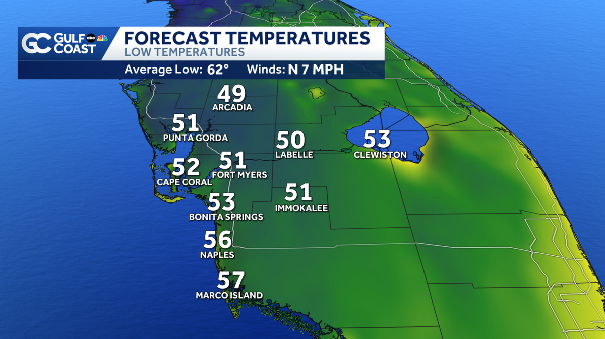
As the sun sets, local communities are bracing for a notably frigid night. Meteorologists are tracking widespread temperatures in the 40s and 50s, a significant departure from the typically mild coastal evenings Floridians are accustomed to. For inland communities, the drop will be even more pronounced, with many areas expected to see overnight lows dipping into the upper 40s before sunrise.
Despite the sharp drop in mercury, the region will be spared from the complications of stormy weather. The current cold snap is moving through with dry air, meaning there is no precipitation in the forecast for the next 24 hours. Residents can expect clear, starry skies tonight, which will only encourage the heat to radiate away from the ground, deepening the chill.
“We are seeing the coldest air of the season make its way down the state,” said meteorologist Raphael Tavernier of the Gulf Coast News weather team. “It is a significant change in the pattern, but the good news is that the dry air ensures we won’t be dealing with rain as temperatures reach these lower levels.”
As residents wake up on the following morning, they should prepare for a brisk start to the day. The lower 50s and upper 40s will linger through the early hours, making for a cold commute. However, relief is on the horizon. Skies are expected to remain mostly sunny throughout the day, providing a pleasant, if cool, backdrop for outdoor activities. By the afternoon, a shift in wind direction is expected to take place. Winds will begin to pick up from the east, acting as the catalyst for a gradual warming trend that will define the remainder of the week.
While the current conditions are cold, the weather pattern is set to shift significantly by the start of next week. Forecasters are monitoring a transition toward warmer conditions, though this shift will also bring more unsettled weather. Residents should be prepared for an increase in humidity and wind speeds, along with the return of small, localized rain chances as moisture levels rise.
For those looking to keep a close eye on the thermometer in real time, the Gulf Coast News weather team encourages the use of the Live Interactive Radar, available on the station’s website and mobile application. With temperatures shifting rapidly over the coming days, keeping updated with the most accurate forecast will be essential for planning the week ahead.
Disclaimer: This content is auto-generated for informational purposes only.
Source: Read Original News