








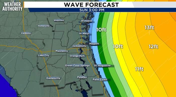
JACKSONVILLE, Fla. – Residents across Northeast Florida are bracing for a difficult stretch of weather as a potent combination of gusty winds, heavy coastal showers, and significant tidal flooding takes hold of the region. Authorities have issued a series of urgent weather alerts, with officials warning that the conditions will persist through the early part of the week.
A Coastal Flood Warning remains in effect through early Wednesday morning for the entire Atlantic coast, including the Intracoastal Waterway and the St. Johns River basin. Meteorologists expect moderate flooding to occur around high tide, which could be exacerbated by incoming showers. The influx of water is raising concerns about infrastructure and road safety in low-lying areas, particularly as onshore winds continue to push water toward the coastline.
The wind itself remains a primary concern for local officials. A Wind Advisory is active for coastal areas through this evening and may be extended into Monday afternoon. Residents are being cautioned to prepare for powerful gusts ranging between 35 and 45 mph. These winds are not only making travel difficult but are also driving dangerous surf conditions and a high risk of rip currents along area beaches. Experts have warned that the combination of high tide and heavy wave action could lead to major beach erosion, urging beachgoers to stay out of the water until conditions improve.
Marine interests are also under threat, with a Gale Warning currently in effect for local Atlantic waters through Monday night. The rough seas and high-speed winds have rendered the area extremely hazardous for small vessels, and mariners are being advised to remain in port until the weather pattern shifts.
While the coast deals with the brunt of the storm, weather impacts remain split across the region. Inland areas are expected to stay mostly dry, offering a reprieve from the precipitation affecting the beachfront. Temperature ranges will be distinct, reflecting the proximity to the coast; highs will hover in the low 70s near the ocean, while inland areas may see temperatures climb to around 80 degrees.
As the region moves into Monday, the forecast offers little immediate relief. The clouds will linger, with continued chances for coastal showers throughout the day. While inland temperatures may reach the low 80s, the coast will stay slightly cooler and breezy. Monday night is expected to turn noticeably cooler for those inland, while the coastline will remain mild but windy as the moisture continues to churn onshore.
Residents are urged to monitor local updates, exercise extreme caution if driving near the coast, and avoid swimming in the Atlantic until all safety warnings have been lifted by the National Weather Service.
Copyright 2026 by WJXT News4JAX – All rights reserved.
Disclaimer: This content is auto-generated for informational purposes only.
Source: Read Original News