









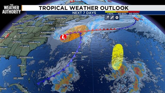
Meteorologists are closely monitoring a developing weather system in the Atlantic, as Invest 93 shows signs of strengthening into a subtropical storm. According to the latest advisory, the system has begun acquiring subtropical characteristics over the last 24 hours, marked by more organized thunderstorm activity and a diminishing reliance on frontal features near its center.
Forecasters currently estimate a 50 percent chance of tropical or subtropical development for the system over the next 48 hours. If current trends continue, the system could reach subtropical storm status as early as tonight or Thursday. The storm is expected to accelerate toward the northeast during this window. However, forecasters expect this period of development to be short-lived, as unfavorable upper-level winds and cooler water temperatures are projected to hinder the system’s growth by Friday.
Regardless of whether the system officially gains a name, coastal residents along the U.S. East Coast are being urged to prepare for significant impacts. High winds, localized coastal flooding, and dangerous surf conditions are anticipated across portions of the coastline over the next several days. Authorities are advising mariners and beachgoers to exercise extreme caution as these conditions develop.
While the primary focus remains on Invest 93, the National Hurricane Center is also tracking a separate area of concern. A new trough of low pressure located several hundred miles east-southeast of Bermuda is currently producing a large, disorganized area of showers and thunderstorms.
The potential for development for this second system remains low, with a 10 percent chance of formation over the next 48 hours and through the next seven days. This system is currently moving slowly to the north-northeast. Like its counterpart, this disturbance is expected to encounter hostile upper-level winds by the weekend, which will likely prevent further organization.
As the Atlantic remains active, weather officials emphasize the importance of monitoring local forecasts. Even systems that fail to reach tropical storm status can produce severe maritime hazards and coastal weather threats. Residents in the path of potential coastal impacts should stay alert for further updates from their local emergency management offices and the National Weather Service.
Invest 93 serves as a timely reminder of the volatility of the Atlantic basin, even as the season progresses. With the formation chance for the primary system holding steady at 50 percent, the next 24 to 48 hours will be critical in determining the extent of the impacts on the U.S. coastline. Updated bulletins will be issued as new satellite data becomes available.
Copyright 2026 by WJXT News4JAX – All rights reserved.
Disclaimer: This content is auto-generated for informational purposes only.
Source: Read Original News