








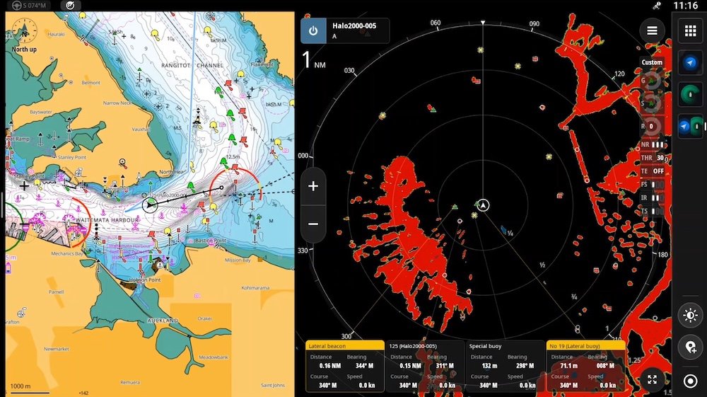
Simrad Marine Electronics is setting a new benchmark for nautical safety with the launch of a sophisticated “Navigation Aid” feature for its recreational radar systems. Designed to reduce cognitive load for boaters, the update integrates advanced mapping intelligence directly into the radar display, providing a clearer, more intuitive visual representation of the marine environment. This update—which also extends to B&G radar systems—marks a significant step forward in the integration of chart plotter data with active radar monitoring.
## Bridging the Gap Between Radar and Charting
For decades, radar has been the primary tool for identifying moving vessels and unpredictable hazards, while charting software has served as the static map for navigation. Previously, captains often had to toggle their focus between two separate displays or mentally synthesize information from both to distinguish a physical buoy from a moving boat.
The new Navigation Aid feature solves this by pulling data directly from C-MAP® premium charts and overlaying it onto the radar screen. By using automated icons to label channel markers, special markers, and other navigational aids, the system allows operators to instantly differentiate between static navigational infrastructure and other radar targets. This “single-pane-of-glass” approach is similar to the trend in automotive technology where augmented reality overlays help drivers see lane markings and obstacles in real-time, effectively using data to clean up the visual noise of the screen.
## Empowering Boaters Through Advanced Tech
Yasser Nafei, President of Electronic Solutions at Navico Group, emphasized that this innovation is aimed at improving real-time decision-making. By leveraging existing radar processing capabilities—such as the company’s established AutoTrack feature—the Navigation Aid acts as an intelligent layer that filters out ambiguity.
“By adding navigational aids directly within the radar view, we’re providing a clearer, more complete picture of the surrounding environment,” Nafei stated. This integration demonstrates how tech companies are increasingly using data intelligence to replace manual interpretation, which is vital in high-stress nautical conditions like low visibility or night navigation. By automating the identification of markers, Simrad is helping to reduce human error, which remains a leading cause of navigational incidents on the water.
## Compatibility and Software Integration
The Navigation Aid feature is designed to function as a seamless software update rather than a hardware overhaul. It is scheduled for deployment in the fourth quarter of 2026, coinciding with the release of the NEON™ OS 2.6 operating system. This software-centric update highlights the industry’s shift toward “Software-Defined” marine electronics, where existing hardware gains new capabilities through cloud-synchronized updates.
Owners of compatible Simrad multifunction displays—including the NSX®, NSX® ULTRAWIDE, NSS® 4, and NSO® 4 lines—will gain access to this functionality, provided they are using C-MAP® DISCOVER® X or REVEAL® X charts. The rollout also covers a wide range of B&G systems, including the Zeus® S and Zeus SR series. Users will retain full control over their interface, with the ability to toggle the navigation overlays on or off via the “Vessels and Targets” menu.
This update reflects a broader trend in the tech industry: the convergence of disparate sensor data into a unified, AI-supported stream. As maritime electronics continue to evolve, the focus is clearly shifting from merely displaying raw sensor data to providing high-level, actionable insights. By making navigation more intuitive, Simrad is not only making the water safer but also making the boating experience more accessible for a new generation of recreational mariners who rely on data-rich, smartphone-inspired interfaces. For professional and recreational captains alike, the integration of navigational intelligence into the radar view represents a major leap toward more confident, informed, and safer operation of marine vessels.
Disclaimer: This content is auto-generated for informational purposes only.
Source: Read Original News