









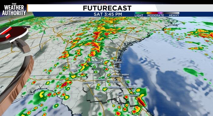
Residents across Northeast Florida and Southeast Georgia are on alert today as a series of severe thunderstorms moves through the region. A Severe Thunderstorm Warning has been issued for portions of Clay, Saint Johns, and Duval counties, currently slated to remain in effect until at least 3:30 PM.
The volatile weather pattern is expected to persist throughout the day, with meteorologists closely monitoring the risk of tornadoes in both Southeast Georgia and Northeast Florida until 9 PM this evening. While the threat remains localized, the atmospheric conditions have prompted officials to urge caution as the region experiences a mix of partly to mostly cloudy skies and unseasonably warm air pushed in by southern winds.
Conditions are expected to deteriorate further as the evening progresses. Forecasters anticipate that wind gusts will reach between 15 and 20 miles per hour through Saturday evening. The most intense activity is projected to peak between 5 PM and 10 PM. While the storms are not expected to be widespread across the entire region, residents should be prepared for isolated to scattered thunderstorms that will move through the area sporadically throughout the night.
“Storms will not be widespread; however, there will be isolated to scattered storms off and on throughout the night,” according to weather reports.
Residents can expect some relief late tonight. Current projections indicate that the primary thunderstorm activity should conclude by 11 PM. However, light rain is expected to linger into the early morning hours of Sunday. By sunset, the probability of rain is forecast to drop to approximately 40 percent. Temperatures are expected to trend downward throughout the night, cooling into the mid-70s by Sunday morning.
Authorities are advising residents in the affected areas to keep a close watch on local weather alerts, as conditions can change rapidly. Those in the path of the storm should have a plan in place for potential power outages or hazardous driving conditions caused by heavy downpours and gusty winds.
Emergency management teams are monitoring the situation as the line of storms continues to track across the state. Residents are encouraged to stay tuned to local broadcasts for real-time updates as the system progresses.
Copyright 2026 by WJXT News4JAX – All rights reserved.
Disclaimer: This content is auto-generated for informational purposes only.
Source: Read Original News