








Coastal residents are being urged to prepare for a significant shift in weather patterns this week as a “backdoor” cold front pushes through the region, bringing with it gusty winds, elevated tidal risks, and a change in temperature.
The transition is expected to begin overnight as wind directions shift, setting the stage for a blustery Tuesday. Meteorologists indicate that as the northeast flow strengthens through Thursday, it will usher in slightly drier air, providing a brief period of stability mid-week. However, the primary concern for those living near the water is the potential for tidal flooding. The sustained, strengthening northeast winds are expected to push water into low-lying areas, impacting beaches, the intracoastal waterways, and rivers.
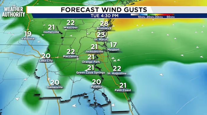
Tuesday’s forecast calls for patchy fog in the early morning hours, followed by a transition to partly cloudy and windy conditions by the afternoon. While inland areas will experience a steady breeze of 10–15 mph, conditions will be considerably more turbulent along the coastline, where wind speeds are projected to reach 20–25 mph, with even stronger gusts possible. Residents should also anticipate a 40–60 percent chance of showers and thunderstorms across Northeast Florida, with a 20–50 percent chance for Southeast Georgia, particularly during the afternoon hours.
By Wednesday, the region will experience a noticeably drier day, offering a brief reprieve from the moisture. Temperatures are expected to trend toward near-seasonal averages throughout the remainder of the work week. Mornings will feel slightly cooler, with lows dipping into the low 70s for Northeast Florida and into the upper 60s for Southeast Georgia, providing a welcome change from recent humidity. However, this period of dryness will be short-lived, as rain chances are forecast to increase again by Thursday and Friday.
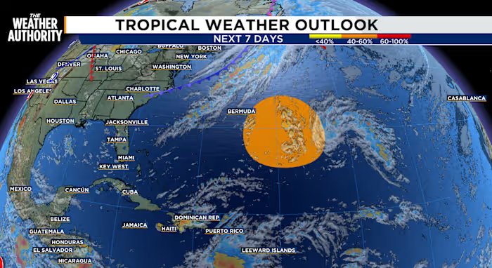
Beyond the immediate local weather, forecasters are keeping a close eye on the Atlantic tropics. A trough of low pressure located approximately 1,000 miles east-southeast of Bermuda is currently producing disorganized showers and thunderstorms. While the immediate formation chance remains low, environmental conditions are expected to become more conducive for development by the middle of the week. Experts are tracking the system as it moves slowly west-northwest over the subtropical Atlantic, assigning a 40 percent chance of tropical depression formation within the next seven days.
For local residents, the priority for the next 48 to 72 hours should be monitoring potential tidal flooding in prone coastal locations and securing outdoor items that could be displaced by high winds. As the front settles in, the combination of brisk northeast winds and shifting rain probabilities suggests a dynamic weather week ahead. Sunrises are scheduled for 7:10 a.m. with sunsets at 7:36 p.m.
Disclaimer: This content is auto-generated for informational purposes only.
Source: Read Original News