






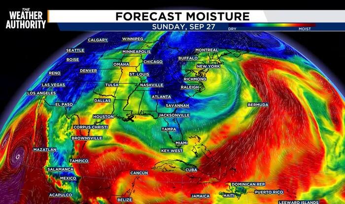
JACKSONVILLE, Fla. – Residents across Northeast Florida can look forward to a refreshing stretch of weather as a strong area of low pressure stationed near New England continues to funnel drier air into the region. This pattern, characterized by steady northerly winds, is set to provide a pleasant, low-humidity reprieve for the remainder of the weekend and through the early part of the coming week.
Tonight will remain mostly clear and cool, with overnight temperatures expected to dip into the 50s and 60s. Sunday will follow suit, offering plenty of sunshine and comfortable conditions. High temperatures are forecast to hold steady near the mid-to-upper 80s, which remains right in line with seasonal averages for this time of year.
The presence of the northerly wind is effectively acting as a barrier against moisture, keeping rain and storm chances out of the forecast through at least mid-week. While temperatures will see a gradual climb back toward the high 80s by Wednesday, the lack of oppressive humidity will keep the atmosphere feeling manageable.
However, meteorologists warn that this dry spell is temporary. Humidity is expected to build back into the region by the end of the work week. By Friday, residents should anticipate the return of isolated rain showers and a slight increase in storm coverage as the local weather pattern begins to shift once more.
In positive news for the region’s long-term outlook, the latest drought monitor report brings welcome updates. Following the beneficial rainfall observed over the past week, drought conditions have shown measurable improvement across the area. Several locations have been downgraded to the lowest category—”abnormally dry”—marking a significant step forward. While the region technically remains in a rainfall deficit, forecasters are optimistic that the expected pattern change heading into the upcoming weekend could yield enough additional precipitation to drive further improvement in future outlooks.
Seven-Day Outlook:
- Tonight: Mostly clear and cool. Low: 56°F.
- Sunday: Mostly sunny and pleasant. High: 86°F, Low: 64°F.
- Monday: Mostly sunny. High: 88°F, Low: 67°F.
- Tuesday: A mix of sun and clouds. High: 89°F, Low: 70°F.
- Wednesday: Sun and clouds, dry. High: 88°F, Low: 71°F.
- Thursday: Sun and clouds, dry. High: 87°F, Low: 73°F.
- Friday: Increasing moisture with isolated rain and storms. High: 87°F, Low: 73°F.
Residents are encouraged to enjoy the dry, comfortable conditions while they last, as the transition back toward typical tropical humidity levels appears imminent for the next weekend.
Copyright 2026 by WJXT News4JAX – All rights reserved.
Disclaimer: This content is auto-generated for informational purposes only.
Source: Read Original News