
As many as 18 counties may hit 40C

Expected South West weather forecast(Image: WXCharts)
Another heatwave may be on the way as temperatures are set to soar again with some expected to get over 40C.
Temperature records have already been shattered this week, with the mercury soaring beyond 37C.
The country witnessed the record for the hottest June day broken on three successive days hitting a peak of 37.3C on Friday (June 26).
Now, the GFS weather model is suggesting that the country could be on the cusp of its hottest day in history. The current all-time record stands at 40.3C, set during the blistering heatwave of July 2022.
A new heatwave looks set to scorch the country within days, with temperatures potentially climbing as high as 35C from July 8.
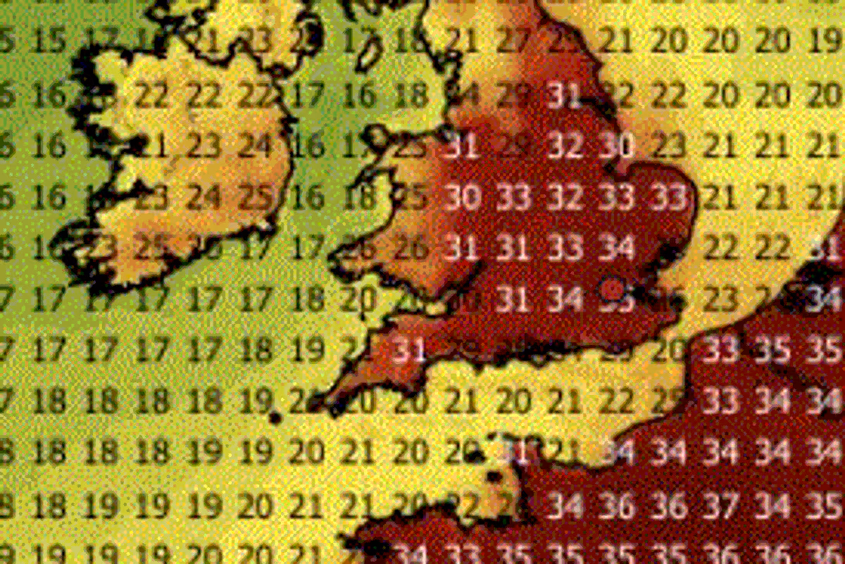
The data suggests that almost all of central and southern England could reach 30C or above, with highs of 33C stretching as far north as Yorkshire.
By July 9, the GFS model data points to possible highs of 37C across southern England, with temperatures in parts of South Wales potentially reaching 32C, reports the Mirror.
Staggering peaks of 40C could be recorded across western and southern England on July 10, with the mercury widely expected to reach between 37C and 39C across central and southern England on what could prove to be the warmest day ever documented.
July 11 is forecast to be even more intense. The GFS model indicates possible temperature peaks of 41C in western England, while vast swathes of the country from Yorkshire down to London could soar to 40C.
Temperatures are then forecast to dip marginally, with peak highs of 38C – predominantly across the south-east – anticipated for 12 July. A comparable outlook is predicted for 13 July, when 37C could represent the maximum temperature.
Temperature anomaly maps for this period show the UK covered in areas of deep red and black. This shows where temperatures are expected to rise well above the seasonal average.
UK counties facing 40C or more in new heatwave:
- Yorkshire
- Nottinghamshire
- Lincolnshire
- Leicestershire
- Derbyshire
- Northamptonshire
- Lancashire
- Cheshire
- Shropshire
- Bedfordshire
- Hertfordshire
- Herefordshire
- Worcestershire
- Warwickshire
- Oxfordshire
- Buckinghamshire
- Berkshire
- Surrey
The Met Office said there is a “greater than normal chance” of further hot weather arriving next month. “Thundery showers” are also possible, according to the national weather agency.
The Met Office long range weather outlook for July 12 to 26 said: “High pressure is looking slightly more likely than low pressure during the early part of this period, meaning a greater chance of settled and drier than average conditions.
“Outbreaks of rain and stronger are possible at times, these more likely further north. As normal for the time of year, there is still a chance of some heavy and thundery showers which may interrupt any warm and settled weather.
“Towards the end of July there is no reliable signal for preferring any one weather pattern over another. However, temperatures are likely to be above normal on the whole, with a greater than normal chance of hot conditions developing at times.”