









ORLANDO, Fla. – The peak of the 2026 Atlantic hurricane season is officially in the rearview mirror, but the record books tell a highly unusual story. As of September 17, the Atlantic basin has yet to produce a single hurricane. With only five weak and brief named storms recorded so far, meteorologists are describing the current atmospheric setup as profoundly strange.
While historically strong El Niño conditions have contributed to the relative silence by generating high levels of upper-level wind shear—which acts to tear apart developing tropical systems—experts note that this is only part of a complex, layered puzzle.
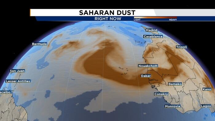
A primary, persistent antagonist throughout the season has been a relentless influx of Saharan Dust. Under normal climate patterns, these plumes of dry, dusty air blowing off the West African coast should have subsided significantly by mid-August. However, the 2026 season has been defined by back-to-back plumes that continue to move across the Atlantic well into September. This continuous barrage of dust has created an exceptionally hostile environment, stripping the atmosphere of the moisture that tropical waves rely on to strengthen and organize into cyclonic systems.
The lack of activity represents a significant departure from typical mid-September intensity, a period usually marked by the height of tropical development across the Main Development Region. As the season progresses into late September and October, the prime window for these West African waves to flourish begins to close, as environmental conditions in the eastern Atlantic become increasingly unfavorable for development.
However, residents should not let their guard down. As the tropical basin transitions into the final phase of the season—which concludes at the end of November—the focus typically shifts toward the western Caribbean and the southern Gulf of Mexico. Meteorological data indicates that these regions often become the “hot spots” for late-season activity.
Current forecast models suggest that upper-level wind shear may relax slightly over the western Caribbean as the calendar turns to October, potentially creating a more hospitable environment for storm formation. While the season has been remarkably quiet to date, the tropics remain unpredictable.
The News 6 Weather team continues to monitor the Atlantic basin closely for any signs of development. As we navigate the remainder of the 2026 season, stay tuned to News 6 for the most accurate and up-to-date tropical tracking information.
Copyright 2026 by WKMG ClickOrlando – All rights reserved.
Disclaimer: This content is auto-generated for informational purposes only.
Source: Read Original News