







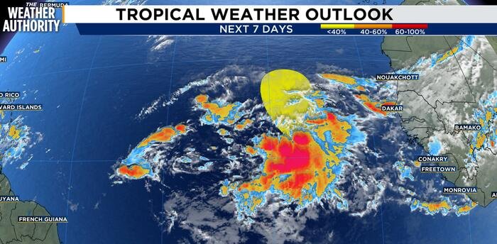
Forecasters at the National Hurricane Center are closely monitoring a new area of low pressure currently situated about 100 miles southwest of the Cabo Verde Islands. The system is generating a broad but disorganized expanse of showers and thunderstorms that stretches hundreds of miles south of the islands.
As of Sunday morning, the system is exhibiting signs of instability, though meteorologists remain cautious regarding its potential for significant growth. The disturbance is expected to track in a north-northwesterly direction over the next couple of days. During this window, environmental conditions may provide a small opening for the system to organize into a tropical cyclone.
However, the window for intensification is expected to be short-lived. Forecasters warn that by the middle of the week, increasing upper-level winds are likely to disrupt the system, creating an environment unfavorable for further tropical development.
Regardless of whether the disturbance manages to attain tropical status, the region should prepare for adverse weather. The National Hurricane Center notes that the system is expected to bring very heavy rainfall to portions of the Cabo Verde Islands over the coming days, which could lead to localized flooding or hazardous travel conditions in those areas.
Current models indicate that the chances for tropical development remain low. The National Hurricane Center estimates the probability of formation at only 10% over the next 48 hours. Looking further ahead into the next seven days, the chance of development remains at 20%.
Meteorologists at the News4Jax Weather Authority are continuing to track the system’s movement and its potential impact on the surrounding region. Residents in the path of the system are encouraged to keep a close watch on local weather updates throughout the week as the situation evolves.
While the current odds are low, this system serves as a reminder that the peak of the tropical season requires vigilance. Further updates will be provided as more data becomes available from the National Hurricane Center.
Disclaimer: This content is auto-generated for informational purposes only.
Source: Read Original News