









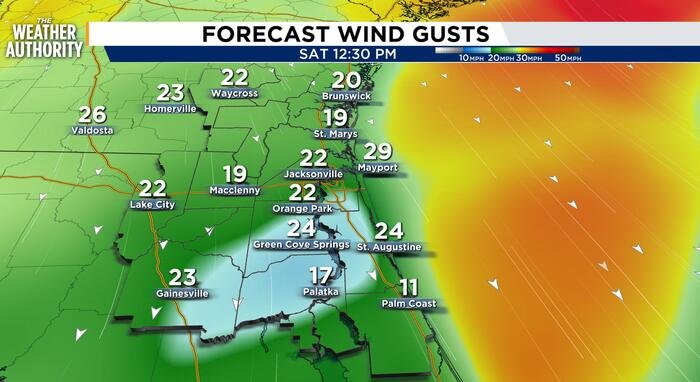
Residents across Northeast Florida are enjoying one final stretch of mild, above-average temperatures before a significant weather shift arrives this weekend. While the region is currently basking in mostly sunny skies and warm conditions, meteorologists are tracking the development of a powerful nor’easter set to sweep through the area beginning late Friday night.
Through the end of the work week, local weather will remain pleasant, though motorists should exercise caution during the morning commute. As high pressure builds across the region, light and calm winds are expected to trigger patchy to dense fog in inland areas through Friday morning. Dense fog advisories could be issued as visibility drops, making for potentially hazardous driving conditions during the early hours.
However, the pattern will change dramatically by Saturday morning. A cold front is forecasted to push southeast across the region late Friday, allowing a strong area of high pressure to build in from the northwest. This atmospheric transition will bring a sharp, uncomfortable shift in conditions, as temperatures are expected to drop by 8 to 10 degrees heading into the weekend.
The arrival of the nor’easter will bring gusty conditions to the coastline. Residents can expect sustained onshore winds between 20 and 25 mph, with powerful gusts reaching 30 to 40 mph. These winds will be accompanied by isolated to scattered showers and the possibility of embedded thunderstorms.
The impact of this weather system will be felt most acutely along the coastlines of Duval, St. Johns, and Flagler counties, as well as the St. Johns River Basin. Forecasters are warning of a High Risk of Rip Currents throughout the weekend, which will linger into early next week. Furthermore, the combination of elevated onshore winds and high tides has raised concerns regarding minor tidal flooding. With local beaches already weakened by previous storms, officials are bracing for additional beach erosion as the nor’easter persists through Tuesday.
For those planning weekend activities, the outlook is significantly cooler and breezier than the current conditions. While Friday remains mostly sunny with highs in the 80s, the mood will dampen by Saturday afternoon as clouds move in. Rain chances will remain highest near the beaches through the early part of next week.
As of Thursday, residents are encouraged to monitor local weather updates, particularly if living in flood-prone areas along the coast or river basin. The brief return to calm, sunny weather is a final respite before the region enters a period of turbulent, wind-driven conditions. For those traveling, keep a close eye on early-morning fog advisories Thursday and Friday, and prepare for the breezy, cooler weather that will define the upcoming weekend.
Disclaimer: This content is auto-generated for informational purposes only.
Source: Read Original News