









JACKSONVILLE, Fla. – After a soggy and turbulent start to the month, residents across Northeast Florida can finally trade their umbrellas for sunglasses. A significant shift in the weather pattern has taken hold, bringing a welcomed stretch of dry, comfortable conditions to the region.
High pressure has officially moved overhead, acting as a stabilizing force that is clearing out the remnants of recent storms. This system is ushering in a northwesterly wind, which is effectively scrubbing the lingering humidity from the air and replacing it with a crisp, dry breeze. For those tired of the persistent rain, today marks a definitive turn toward a more pleasant and sunny autumn-like feel.
Temperatures are expected to remain quite comfortable throughout the week, with daily highs consistently landing in the low to mid-80s. The influx of drier air means that the threat of rain has been effectively neutralized, with no precipitation forecast for the next several days.
The arrival of this high-pressure system comes at a time when the region is seeing positive developments in its long-standing battle with dry conditions. The latest drought monitor update indicates marked improvement across the area. Several counties have been downgraded to the lowest category of drought intensity, a direct result of the significant and much-needed rainfall that soaked the region over the past week.
Looking ahead, the pleasant pattern is expected to hold firm. Forecasters say high pressure will remain in control for the duration of the work week, keeping skies mostly sunny or partly cloudy with highs settling near 86 or 87 degrees each day.
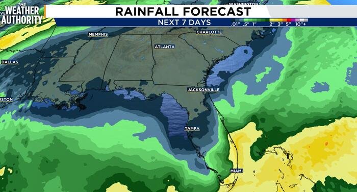
A change in the forecast is currently being tracked for the upcoming weekend. A cold front is expected to approach the region, but early projections offer good news: rainfall coverage looks to remain isolated. While the front will likely move through the area, the most widespread storm activity is currently tracking toward the southern portions of the state. Following the frontal passage, residents should prepare for a return of windier conditions, driven by a secondary area of high pressure settling in behind the front.
Weekly Outlook:
- Today: Mostly sunny, high of 86 and low of 65.
- Tuesday: A mix of sun and clouds, high of 87 and low of 67.
- Wednesday: Continued sun and clouds, remaining dry, high of 86 and low of 67.
- Thursday: Mostly sunny conditions, high of 87 and low of 67.
- Friday: Sun and clouds, high of 87 and low of 66.
As the region enjoys this period of stability, meteorologists encourage residents to take advantage of the dry weather before the weekend front brings a shift in the breeze.
Disclaimer: This content is auto-generated for informational purposes only.
Source: Read Original News