








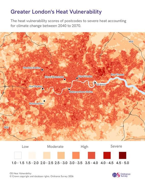
The City of London has been identified as the most heat-retentive urban environment in Great Britain, according to a comprehensive new analysis by Ordnance Survey (OS). As record-breaking summer temperatures become the new baseline, the dense architectural landscape of the capital is trapping solar heat, creating a “heat island” effect that poses an escalating risk to public health and the economy.
The study, which utilized advanced mapping of building density, hard-surface coverage, and natural cooling elements like tree canopies and water, reveals a precarious future for British urban centers. Urban heat islands form when concrete, asphalt, and tall buildings absorb solar radiation throughout the day. Unlike rural environments, which benefit from natural ventilation and rapid nocturnal cooling, these built-up areas retain heat well into the night. Narrow streets and high-rise clusters further restrict airflow, preventing the natural dispersion of heat that might otherwise provide relief.
The OS Heat Vulnerability Index highlights the City of London as the most critically affected area, citing its high concentration of “made” surfaces and the lowest availability of green or blue infrastructure of any city in Britain. The City of Westminster ranks a close second, with both areas projected to reach “severe” heat vulnerability levels between 2070 and 2100.
The human and financial toll of this phenomenon is already significant. Research published in The Lancet Planetary Health linked the urban heat island effect to roughly 399 of the 785 heat-related deaths in Greater London during the summer of 2018. The social cost of these deaths has been estimated at nearly £1 billion. Furthermore, data supporting the “Heat Ready London” initiative indicates that the 2022 heatwaves resulted in an economic impact of £1.5 billion, encompassing losses in labor productivity, disruptions to education and transport, and overwhelming demand on emergency services.
The national outlook is equally sobering. Ordnance Survey analysis confirms that 83% of Britain’s cities are already categorized as highly vulnerable to extreme heat retention. As climate change continues to drive up average summer temperatures, this geographical vulnerability is expected to intensify. By 2040, every city currently identified as having moderate exposure is projected to shift into the high-vulnerability category. By the end of the century, 63% of British cities are expected to reach the “severe” threshold, necessitating a fundamental rethink of urban planning and climate adaptation.
The data underscores that the issue is not merely one of discomfort; it is a critical structural challenge. The lack of vegetation and water sources exacerbates the lack of natural shading and evaporative cooling, which are vital for mitigating extreme temperatures.
As the geography of urban heat evolves, the findings serve as a stark indicator that current urban infrastructure is becoming increasingly unfit for a warming climate. For densely populated centers, the challenge now lies in how to integrate green and blue spaces into existing, highly developed environments to prevent further heat retention. Failure to adapt, experts warn, will place an unsustainable burden on energy grids, transportation networks, and the health of the most vulnerable populations.
The OS analysis acts as a vital tool for policymakers, offering the data-driven foresight required to redesign cityscapes to withstand the intensifying climate of the coming decades. With projections showing a near-universal increase in heat vulnerability across Britain, the transition toward heat-resilient urban design is moving from a localized concern to a national imperative.
Disclaimer: This content is auto-generated for informational purposes only.
Source: Read Original News