








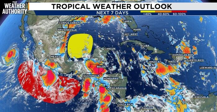
Forecasters are closely monitoring the southwestern Gulf of Mexico as an active weather pattern takes shape, with meteorologists suggesting that a low-pressure system could form in the region later this week.
An upper-level low currently spinning over the Bay of Campeche is the primary driver of the unsettled weather. This system is already fueling widespread, scattered showers and thunderstorms across portions of the Gulf region. The atmospheric disturbance is also intensifying storm activity over the Isthmus of Tehuantepec in southern Mexico, serving as a reminder of the region’s current instability.
According to the latest meteorological observations, a surface trough is currently stretching from southeastern Louisiana down through the central Bay of Campeche. The wind flow around this trough remains distinct; areas to the east of the axis are experiencing fresh southeasterly winds, while the region to the west is seeing notably lighter and more variable conditions.
Marine conditions across the Gulf are currently described as moderate. While deeper waters may see more active seas, current reports indicate that wave heights in the Bay of Campeche remain relatively calm, holding between 1 and 3 feet.
While the presence of the system is clear, the long-term outlook remains uncertain. As of the latest update, the National Hurricane Center (NHC) has placed the system at a 30 percent probability for tropical development over the next seven days.
The Weather Authority team is continuing to track the movement and structure of this system. Because the Gulf of Mexico is highly sensitive to shifts in upper-level wind patterns and water temperatures, even minor changes in the coming days could influence whether the system organizes further or dissipates as it moves across the basin.
Residents with interests in the Gulf of Mexico, including mariners and those in coastal communities from Louisiana to Mexico, are encouraged to stay tuned to local forecasts throughout the week. Meteorologists will be analyzing satellite imagery and data from weather models to determine if the system gains any significant organization as it interacts with the warm waters of the Bay of Campeche.
For now, the situation is not cause for immediate alarm, but it remains a developing story. As the week progresses, updated guidance from the National Hurricane Center will provide a clearer picture of whether this system poses a broader threat or simply remains an area of disorganized, albeit active, weather.
Copyright 2026 by WJXT News4JAX – All rights reserved.
Disclaimer: This content is auto-generated for informational purposes only.
Source: Read Original News