


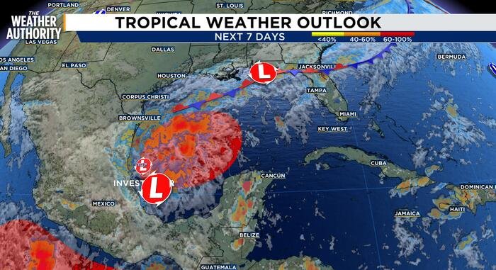
A developing weather system in the southwestern Gulf of Mexico has triggered heightened concern as meteorologists monitor a trough of low pressure expected to organize later this week. The system is currently producing scattered, disorganized showers and thunderstorms, but environmental conditions are shifting in a way that favors gradual strengthening.
Forecasters warn that there is a significant probability that this disturbance will continue to consolidate, with current data showing a 60% chance of tropical depression formation over the next few days. Looking further ahead, that probability increases to 80% over the next seven days. Should the system achieve the necessary threshold for organization and wind speeds, it will be designated as Tropical Storm Isaias.
Current computer models suggest the system will drift in an eastward direction over the next 48 hours. Following that initial movement, the prevailing steering currents are expected to pull the system into a northward turn. While exact landfall locations and specific intensity forecasts remain premature, the system’s projected track has placed the northern Gulf Coast on high alert.
Meteorological agencies are noting discrepancies between leading forecast models, which is common in the early stages of storm development. For instance, the Global Forecast System (GFS) currently suggests the system may struggle to maintain significant structure. Conversely, the European model is more aggressive, indicating the potential for a more robust development that would lift the system directly toward the Louisiana and Mississippi Gulf coastlines.
“It is too early to determine the specific impacts to the northern Gulf Coast,” weather officials stated in an advisory. “However, interests in that region should closely monitor the progress of this system as it evolves throughout the week.”
Residents in potentially affected areas are encouraged to stay updated as the storm progresses. With formation chances steadily climbing, local emergency management agencies are likely to begin coordinating preparedness efforts. Because the path remains uncertain, officials urge residents from the Texas coast through the Florida Panhandle to review their hurricane plans and keep a close eye on updates from their local weather authorities.
The system serves as a reminder of the volatility of the Gulf of Mexico during the hurricane season, where atmospheric conditions can rapidly turn a disorganized trough into a significant weather event. As the middle of the week approaches, clearer satellite imagery and reconnaissance data will be vital in providing a more definitive trajectory and intensity forecast for the evolving storm.
Disclaimer: This content is auto-generated for informational purposes only.
Source: Read Original News