









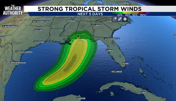
Tropical Storm Isaias is showing signs of renewed vigor, becoming better organized over the past several hours as it churns through the Gulf of Mexico. Meteorologists at the National Hurricane Center report that a large area of deep convection has developed near and northeast of the storm’s center, signaling a steady intensification trend.
Data gathered by NOAA Hurricane Hunters confirm that the system is currently shifting its structure. The center of the storm was located near latitude 22.6 North, longitude 93.4 West, with reconnaissance flights revealing that the circulation center has successfully re-formed slightly to the north of previous estimates.
As of the latest advisory, maximum sustained winds have increased to near 50 mph, accompanied by higher gusts. Forecasters anticipate continued strengthening over the next 48 hours, with Isaias projected to reach hurricane status by Thursday. The system is presently moving toward the east-northeast at roughly 8 mph. This trajectory is expected to persist through the day before the storm makes a critical turn toward the northeast and north on Thursday and Friday.
Residents along the U.S. northern Gulf Coast are being urged to monitor the system closely, as Isaias is forecast to pass north of the Yucatan Peninsula on Thursday before approaching the coastline on Friday. Currently, tropical-storm-force winds extend outward up to 45 miles from the center, and the minimum central pressure has dropped to 997 mb.
Beyond the wind threat, heavy rainfall poses a significant danger. Coastal areas of the Bay of Campeche can expect 2 to 4 inches of rain through Thursday, with localized higher totals in the states of Campeche and western Yucatan.
The threat escalates as the storm approaches the United States. From Friday through the weekend, meteorologists predict rainfall totals of 3 to 6 inches, with localized amounts reaching up to 10 inches, across the central U.S. Gulf Coast from southeastern Louisiana to the Florida Panhandle. Additionally, as the system tracks inland, rainfall amounts of 1 to 3 inches—with isolated totals up to 5 inches—are possible across the Southeast, stretching as far north as the Tennessee Valley and the Carolinas.
Authorities warn that these heavy downpours will likely trigger flash and urban flooding, alongside the potential for isolated river flooding. Residents in the projected path are advised to finalize their emergency preparations immediately, as the window to ready homes and businesses for potential hurricane-force conditions is narrowing. Emergency management officials urge the public to keep a close watch on local weather alerts as the storm’s intensity and track evolve over the coming days.
Copyright 2026 by WJXT News4JAX – All rights reserved.
Disclaimer: This content is auto-generated for informational purposes only.
Source: Read Original News