






Monitoring Ocean Health with PACE Satellite Technology
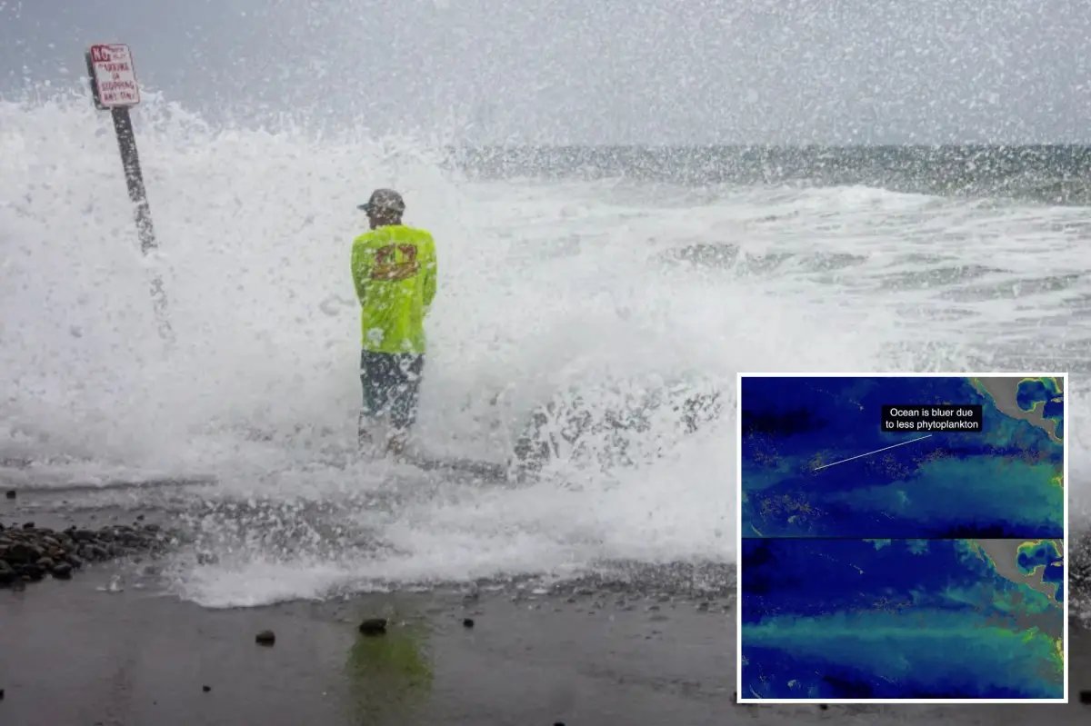
The recent dramatic transformation of the Pacific Ocean from a lush green to a vibrant Cerulean blue has provided researchers with a unique opportunity to test the capabilities of next-generation satellite observation systems. As the current Super El Niño event alters the physical and biological characteristics of the equatorial Pacific, NASA’s Plankton, Aerosol, Cloud, ocean Ecosystem (PACE) mission is serving as the primary tool for documenting these changes. By leveraging advanced sensors, PACE enables scientists to move beyond simple temperature mapping and perform detailed spectral analysis of the ocean’s surface.
The transition in water color is not merely a visual shift; it is a profound indicator of biological disruption. Satellites equipped with multi-spectral radiometers measure the light scattered and absorbed by the upper layers of the ocean. Phytoplankton, the microscopic organisms that form the foundation of the marine food web, contain chlorophyll and other pigments that typically cast a green hue across the water. When the Pacific turns Cerulean blue, it indicates a significant reduction in these organisms, revealing the deep, clear water beneath. This transition is a technical metric used by oceanographers to quantify the intensity of environmental stress caused by shifting weather patterns.
The Mechanism Behind Phytoplankton Decline
To understand why the Pacific is changing color, one must look at the mechanics of ocean upwelling. Under normal conditions, trade winds move across the surface of the Pacific, pushing warmer surface waters westward and allowing cold, nutrient-rich water from the deep ocean to rise to the surface. This process creates a cycle of biological productivity. Phytoplankton thrive in these nutrient-dense conditions, which effectively turn the water shades of green or brown.
During the El Niño phase of the El Niño–Southern Oscillation (ENSO), these trade winds weaken significantly. Without the force of the winds to drive the upwelling, the cold, nutrient-rich water remains trapped at depth. The surface layer becomes dominated by warmer, nutrient-poor water. Deprived of the phosphorus, nitrogen, and iron essential for their growth, phytoplankton populations experience a rapid decline. Satellite imaging captures this “biological desertification” in real-time, providing a high-resolution map of where marine life is struggling to survive. The shift to blue is, therefore, a technical indicator of a broken nutrient cycle.
Advancing Predictive Modeling for ENSO Events
The ability to track these color changes is vital for predictive modeling. Current research utilizes data from the PACE mission to correlate ocean color with sea surface temperature anomalies. Since 1950, scientists have cataloged the intensity of various ENSO cycles, but modern sensor technology allows for much greater precision. With sea surface temperatures in the eastern Pacific currently sitting 3 degrees above the long-term average, climate models are being stress-tested against historical data.
The integration of satellite-derived biological data with oceanic temperature readings allows researchers to predict how these environmental shifts will ripple through the food chain. When primary producers like phytoplankton disappear, it impacts the entire trophic structure, from small forage fish to larger marine predators. By monitoring the color of the Pacific, scientists can estimate the duration and severity of the current El Niño event, providing essential data for international meteorological organizations to adjust their long-term forecasts for weather patterns and precipitation levels across the globe.
Assessing Infrastructure Risk and Sea Level Rise
Beyond the biological implications, the current El Niño event poses severe mechanical and structural risks to coastal regions. One of the most critical aspects of this phenomenon is the development of oceanic Kelvin waves. These waves are large-scale disturbances that travel across the Pacific, effectively moving massive volumes of warm water toward the coast. These waves can elevate sea levels by up to 12 inches, creating a high-risk scenario for coastal infrastructure.
Technical assessments of the current situation suggest that the combination of elevated sea levels, increased tidal intensity, and powerful winter storms creates a compounding risk for coastal communities. Engineering firms and government agencies are using this satellite-derived data to identify the most vulnerable zones for flooding and erosion. The shift in color is a key signal that the oceanic architecture is changing, providing a warning that static coastal defenses may be insufficient for the projected surges. Emergency management systems are incorporating these oceanic observations to ensure that early warning protocols are active before peak storm activity reaches the coastline.
Observing Ecological Displacement and Invasive Presence
The change in the Pacific’s environment is also reflected in the migration patterns of marine life, which have become increasingly erratic. As the nutrient-rich water retreats, local species are forced to move to find viable habitats. Simultaneously, the intrusion of warmer water facilitates the arrival of species from lower latitudes. The presence of whale sharks, hammerhead sharks, and venomous sea snakes in waters traditionally considered too cold for their permanent residence is a diagnostic indicator of a shifting ecosystem.
Researchers are tracking these migrations to understand the long-term impact on biodiversity. The displacement of indigenous species is not just a temporary curiosity; it marks a transformation in the coastal ecosystem that may have lasting effects on local fisheries and biodiversity indices. By correlating the satellite data on water color and temperature with biological sightings, scientists can build a more comprehensive picture of how large-scale climate oscillations facilitate the movement of species and force rapid adaptation in maritime environments. This data serves as a framework for policy decisions regarding fishing regulations and protected marine areas as the climate continues to deviate from historical norms.
Disclaimer: This content is auto-generated for informational purposes only.
Source: Read Original News