








Satellite Imagery Reveals Hidden Tidal Variations at the Beach Scale
For decades, scientists have relied on stationary tide gauges and coarse satellite radar to track the movement of our oceans. However, new research reveals that these systems have been missing a critical piece of the puzzle: tides can vary by as much as a meter across a single bay, creating localized risks that traditional models often fail to capture.
A groundbreaking study led by researchers at the Technical University of Munich (TUM) and the University of Oxford has introduced a novel technique that estimates tidal levels at 100-meter intervals along the coast. By leveraging decades of archival satellite imagery, this method offers a granular view of coastal dynamics previously thought impossible to achieve. The findings were recently published in the journal Nature Communications: Earth and Environment.
Using the Beach as a Ruler
Historically, measuring tides from space has been hampered by technical limitations. Conventional radar satellites typically provide data with a resolution of tens of kilometers, while physical tide gauges are geographically sparse.
To overcome this, the research team turned to the Landsat program, NASA’s long-running satellite mission. Instead of attempting to measure the height of the sea directly from the images, the researchers utilized the shoreline itself as a “giant ruler.”
As the tide rises and falls, the waterline shifts against the slope of the beach. By recording the waterline’s position in thousands of images and combining this data with precise topographic information about the beach slope, the team successfully calculated exact sea-level changes. Analyzing over 40 years of data along the Pacific coastline, the researchers were able to identify repeating tidal rhythms for individual beach segments.
A Major Shift for Coastal Safety
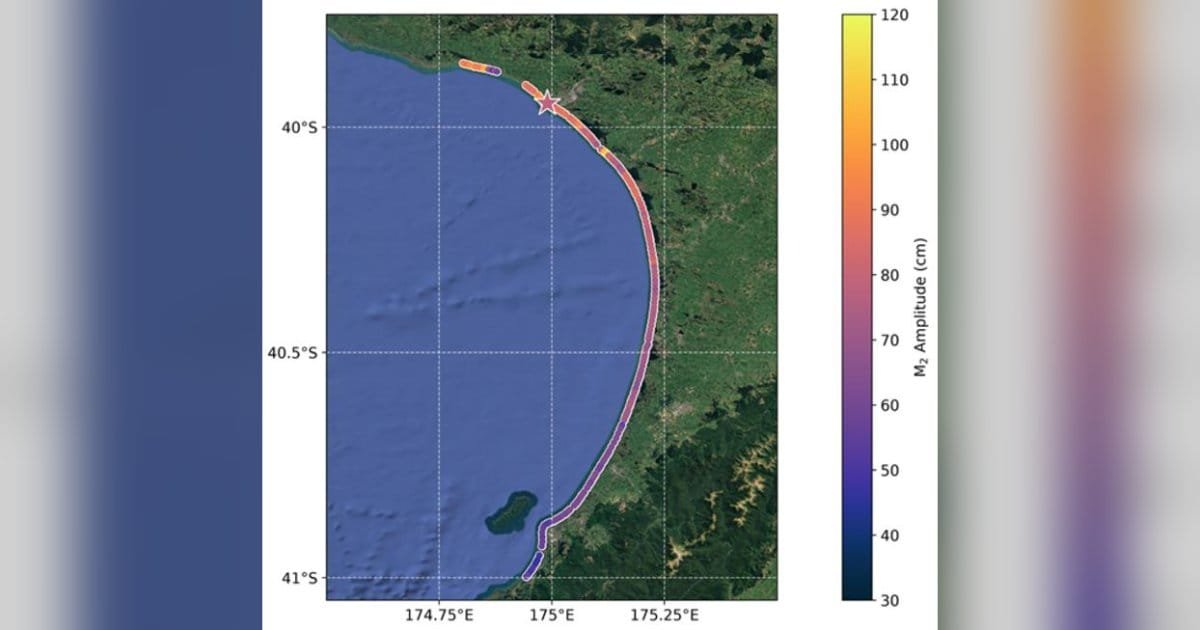
The results revealed significant local discrepancies. In New Zealand’s South Taranaki Bight, for instance, the study identified a one-meter difference in tidal height across a 90-kilometer stretch of coastline. Similarly, near Christchurch, tides in Pegasus Bay were found to be 40 cm higher than those near the Rakaia River just to the south.
“Our research shows that tides can vary substantially over relatively short distances,” explains co-author Dr. Thomas Monahan of the University of Oxford. “This has big impacts on coastal flooding. Short-scale variations in tides can mean the difference between two neighboring regions being safe or flooded for the same storm.”
Dr. Michael Hart-Davis, the study’s lead author from the German Geodetic Research Institute (DGFI-TUM), emphasized the broader implications for public safety and climate resilience. “The coastal zone, where tides have the greatest impact on navigation, pollution, and flooding, remains a gap in oceanographic knowledge,” he noted.
Future Horizons
The ability to measure tides at such high resolution could revolutionize coastal management. By filling in the “blind spots” of the global ocean observing system, scientists hope to improve models for compound flooding, saltwater intrusion, and sea-level rise projections.
The team is already looking toward the future, hoping to integrate data from newer missions like the Copernicus Sentinel-2 satellites. This expansion could allow for near-global coverage, providing essential tidal data for resource-poor regions—such as those in Africa—that currently lack extensive monitoring infrastructure.
For the researchers, the impact is both scientific and personal. “This work is not only of interest to the scientific community, but to all who enjoy visiting coastlines,” Dr. Hart-Davis added. “Having spent my life surfing and swimming in the sea, I know too well how reliant we are on accurate tide tables.”
As climate change accelerates rising sea levels, this high-precision mapping could prove to be a vital tool in helping coastal communities adapt to an increasingly unpredictable environment.