









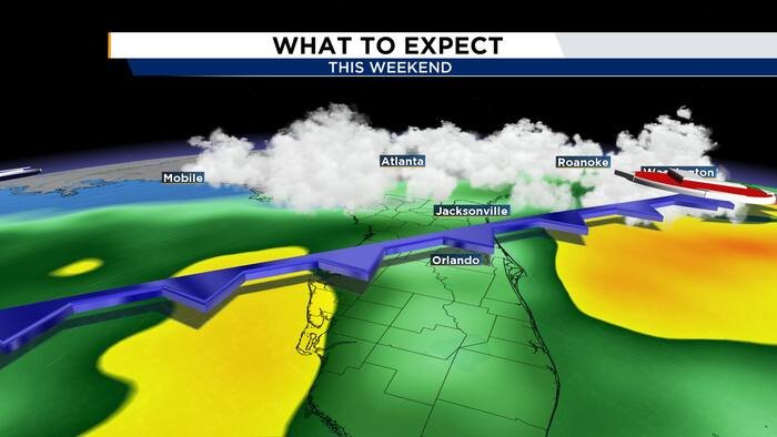
ORLANDO, Fla. – Central Florida is bracing for a significant shift in weather as a cold front moves into the region, promising a brief but dramatic departure from the current sweltering heat. While the week ends on a warm note, residents can expect a transition to cooler, breezier conditions by the second half of the weekend.
The change begins on Friday. After a calm and dry start to the day, meteorologists are tracking increased moisture and instability ahead of an approaching cold front. Residents should prepare for spotty showers and storms to develop around midday, particularly along the Interstate 4 corridor. These downpours are expected to intensify by mid-afternoon, pushing eastward and lingering into the early evening hours. Despite the threat of rain, temperatures will remain high, with daytime highs once again reaching the low 90s.
The transition officially takes hold on Saturday as the cold front pushes across the peninsula. Early Saturday afternoon will bring the best chance for widespread storms as the front tracks through Central Florida. Following the passage of the system, the region will experience a rapid change in wind patterns and air quality.
Beginning late Saturday and continuing through Sunday, winds will shift significantly to the north-northeast. The News 6 Weather team warns that these winds will be quite gusty, with sustained speeds and gusts ranging from 25 to 35 mph. The impact will be most noticeable along the coast, where the strong winds will create rough surf conditions.
This shift in wind direction is set to usher in a much drier and noticeably cooler air mass, providing a refreshing break from recent humidity. By Sunday morning, temperatures are expected to drop into the 60s, a stark contrast to the persistent 90-degree heat experienced earlier in the week. The high temperature on Sunday is projected to reach only the upper 70s to low 80s, marking a pleasant end to the weekend.
As of now, Friday morning will remain relatively quiet before the front initiates the turn toward more unsettled weather. Residents with outdoor plans for the weekend are encouraged to monitor the latest forecasts, as the timing of the front’s arrival and the associated gusty winds could affect beach activities and outdoor events.
The News 6 Weather team will continue to track the movement of this front and provide updates on potential storm development throughout the weekend. With the cooler temperatures arriving just in time for the end of the weekend, it marks a brief, refreshing taste of autumn-like conditions for Central Florida.
Disclaimer: This content is auto-generated for informational purposes only.
Source: Read Original News