








Residents across Northeast Florida and Southeast Georgia should prepare for another round of severe weather as a powerful nor’easter tracks toward the region. While the coming days will begin with deceptively calm and sunny skies, meteorologists are warning of a significant deterioration in conditions heading into the weekend.
The early part of the week will remain cool and crisp, characterized by mostly sunny conditions through Thursday. Temperatures will hover below seasonal norms, with overnight lows dipping into the 40s for parts of Southeast Georgia and Northeast Florida, while coastal areas remain slightly warmer in the 60s. Highs are expected to reach the 70s and low 80s, providing a brief window of stability before the coastal system intensifies.
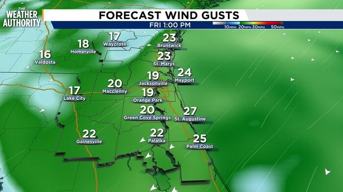
The pattern begins to shift on Friday. A persistent northeasterly flow will strengthen throughout the day, with sustained winds increasing to 15–20 mph. By the weekend, the situation is expected to escalate, with sustained winds reaching the 20 mph range and dangerous gusts projected between 30 and 40 mph.
As these strong onshore winds develop, coastal communities should brace for significant hazards. Forecasters have issued warnings regarding dangerous surf conditions and a high likelihood of coastal flooding. Minor tidal flooding is already occurring along the St. Johns River Basin, but meteorologists anticipate this will escalate to moderate flooding by the weekend. Coastal portions of Northeast Florida are also at high risk for flooding as the relentless northeasterly push piles water against the shoreline.
In addition to the wind and tide concerns, the risk of precipitation will rise significantly. Starting Saturday, wind-driven showers will become more frequent, with rain chances ranging from 50% to 80% along the coast. While Sunday may see some improvement, rain chances will persist between 30% and 60% as the system slowly moves through.
Marine interests should take immediate precautions. Gale conditions are possible across Atlantic waters, and authorities are advising against marine activities due to the volatile sea state and high surf advisories.
Looking ahead, the region will remain in a breezy pattern early next week with lingering chances of light, scattered showers. Residents are encouraged to monitor local updates as the high-tide cycles approach, particularly those living in flood-prone areas near the St. Johns River and the coastline.
With sunrise currently at 7:33 a.m. and sunset at 6:50 p.m., the reduced daylight hours combined with heavy wind and rain will create hazardous driving conditions throughout the weekend. Officials urge all residents to secure loose outdoor furniture and prepare for the potential of localized disruptions due to the high winds.
Disclaimer: This content is auto-generated for informational purposes only.
Source: Read Original News