








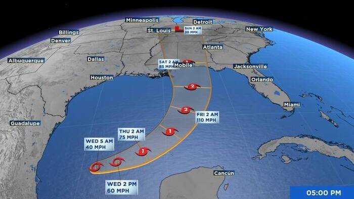
Tropical Storm Isaias officially formed in the Gulf of Mexico early Wednesday morning, and meteorological experts are warning of rapid intensification as the system tracks toward the United States. According to the National Hurricane Center (NHC), the storm is projected to strengthen into a hurricane by Thursday, potentially posing a significant threat to the Gulf Coast.
As of 5 a.m. Wednesday, Isaias was positioned approximately 580 miles southwest of the mouth of the Mississippi River. The storm is currently moving in an east-northeast direction at about 8 mph, packing maximum sustained winds of 40 mph. While the system is still in its early stages, tropical-storm-force winds already extend outward up to 45 miles from the center, and the minimum central pressure was recorded at 1004 mb.
Forecasters expect the storm to maintain its east-northeast trajectory throughout Wednesday before shifting toward the northeast and north on Thursday and Friday. On this projected path, Isaias is expected to pass north of the Yucatan Peninsula before approaching the northern U.S. Gulf Coast by the end of the week.
The NHC has issued an urgent advisory for residents spanning from Louisiana to the Florida Panhandle. Officials are urging citizens to monitor weather updates closely and ensure that hurricane preparedness plans are finalized immediately. Residents should anticipate the potential for hurricane and storm surge watches to be issued for portions of the northern Gulf Coast later today.
The impact of Isaias is expected to be widespread, particularly regarding heavy rainfall. From Friday through the weekend, the northern Gulf Coast—extending from far southeastern Louisiana to the Florida Panhandle—could see rainfall totals ranging from 3 to 6 inches, with some areas facing up to 10 inches of accumulation. Further inland, as the storm tracks toward the Tennessee Valley and the Carolinas, rainfall totals of 1 to 3 inches are anticipated, with localized spots potentially seeing up to 5 inches.
Authorities are warning of the high probability of flash and urban flooding, as well as isolated river flooding, across these regions. In addition to the water hazards, the system is expected to deliver dangerous winds and life-threatening storm surge upon its arrival at the coast.
Meanwhile, impacts are already expected in Mexico, where Isaias is forecast to bring gusty winds and heavy rain to the western Yucatan Peninsula over the next 48 hours.
As the situation remains fluid, local emergency management agencies are coordinating with federal officials to prepare for the storm’s arrival. Residents are encouraged to stay tuned to local broadcasts for the latest warnings and evacuation orders as they become available.
Copyright 2026 by WJXT News4JAX – All rights reserved.
Disclaimer: This content is auto-generated for informational purposes only.
Source: Read Original News