






Expanding Global Coverage for Seismic Monitoring
Google has officially announced a significant expansion and feature enhancement for the Android earthquake alerts system. Originally launched in 2021, this technology leverages the existing hardware sensors within billions of active Android devices to create a massive, decentralized seismic detection network. By turning every phone into a miniature seismometer, the system detects the P-waves—the faster, initial waves generated by an earthquake—and uses this data to alert users in surrounding areas before the more destructive S-waves arrive.
The most notable update in this rollout is the massive expansion of geographical coverage. The system is now operational in over 200 regions globally, a significant increase from the previous count of 98. This expansion marks a concerted effort by Google to bring critical early warning capabilities to areas that are historically prone to seismic activity but may lack the density of traditional, government-funded seismographic station networks. Panama and Guatemala are among the latest nations integrated into this detection grid, providing millions of additional users with potentially life-saving seconds of warning time.
Technical Advancements in Alert Granularity
While the backend infrastructure for detection continues to refine its accuracy through machine learning, the user-facing interface is undergoing a major redesign. Historically, alerts were segmented into broad categories based on the anticipated intensity of the shaking. The new update shifts toward a more data-rich presentation style, particularly for the “Be Ready” tier of warnings.
The system now provides users with a clearer picture of the event, including the estimated epicenter and the projected magnitude of the seismic event. By providing a map that visualizes the radius of detected shaking, users can better understand their proximity to the rupture point. This shift from binary warnings to contextual data enables individuals to make more informed decisions regarding their physical safety, such as moving away from windows or seeking cover under sturdy furniture.
The Three-Tiered Response Framework
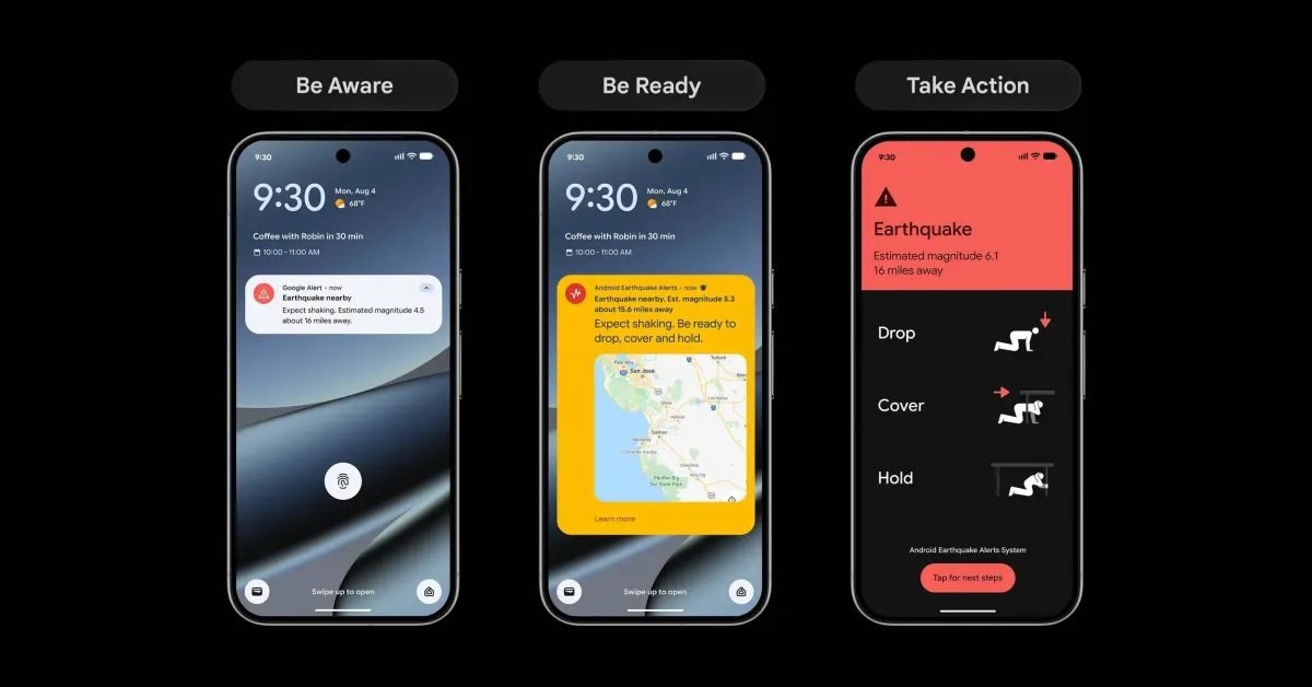
Google has structured the notification system into three distinct categories, each designed to communicate the appropriate level of urgency. These tiers are optimized for different intensity levels, ensuring that the device provides the most relevant guidance based on the expected impact:
Be Aware: This alert is generated when the system detects light shaking. It serves as an early notification for users, keeping them informed of geological events occurring in their vicinity without necessarily requiring immediate emergency action.
Be Ready: This tier is triggered for stronger anticipated shaking. It includes the newly enhanced interface, providing detailed guidance, magnitude estimates, and visual representations of the event, encouraging users to take proactive safety measures.
Take Action: This is the highest level of alert, triggered during moderate to heavy shaking. The interface takes over the entire screen, delivering clear, step-by-step instructions on how to survive the tremors. This design ensures that in high-stress situations, the most critical information is presented without distraction.
Impact and Reliability of Crowdsourced Detection
The effectiveness of this system relies heavily on its crowdsourced nature. When an Android device detects a tremor, it sends a signal to a central server that combines data from thousands of other devices in the same area. This rapid triangulation allows the system to confirm an earthquake is occurring and estimate its magnitude and location almost instantaneously.
While the system has faced challenges, including occasional false alarms and instances of technical failure during complex, multi-fault ruptures, the overall impact remains positive. Google reports that the system has successfully delivered over one billion alerts since its inception. These warnings provide a window of time—often only seconds—which, when multiplied across a population, can result in fewer injuries and a more organized response to emergency protocols. The ongoing refinement of the detection algorithms is designed to reduce false positives while maintaining high sensitivity to early-stage seismic activity.
Improving Crisis Preparedness Through Real-Time Data
The technical evolution of these alerts underscores a broader trend in mobile technology: the transformation of consumer hardware into critical public safety tools. By integrating real-time data visualization into the alert window, Google is essentially providing a pocket-sized emergency management tool for the general public.
In the coming months, the rollout will continue to add more interactive elements, including a persistent button that allows users to access live updates as new seismic data comes in. This ensures that the user is not just a passive recipient of an initial warning, but has access to a continuous stream of information as the event unfolds. This level of transparency is essential for reducing panic and ensuring that those in the affected area can access authoritative, updated guidance. As regional support continues to grow, this system stands as one of the most widespread implementations of real-time disaster alert technology globally.
Disclaimer: This content is auto-generated for informational purposes only.
Source: Read Original News