








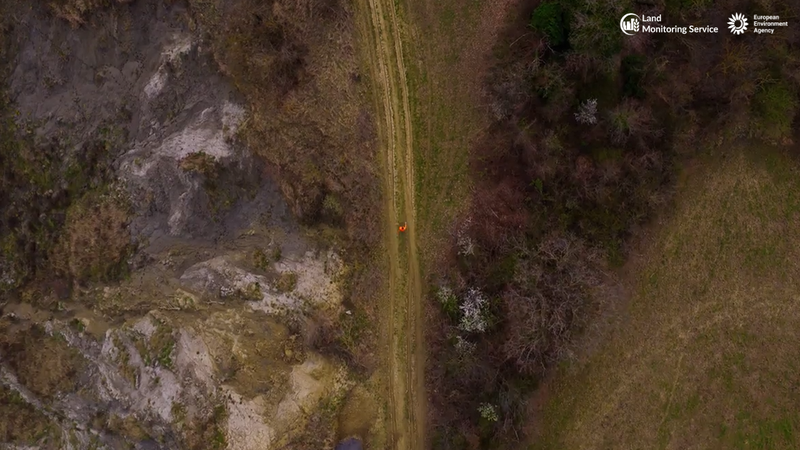
Europe’s diverse geography—spanning from the forests of Sweden to the scrublands of Spain—is currently facing unprecedented pressure, according to a new report from the European Environment Agency (EEA). To visualize the scale of human impact on the continent, the agency released an innovative 100-second film today that utilizes satellite imagery to break down how European land is actually used.
The project, spearheaded by UK-based citizen geographer Daniel Raven-Ellison, draws on high-precision data from the EU’s Copernicus Land Monitoring Service. By condensing the complex data into a digestible visual format, the EEA aims to bridge the gap between scientific observation and public awareness, highlighting how much of the continent is dominated by human activity versus how little remains for wilderness.
“This video gives a unique and new perspective on our many different and valued landscapes,” said Leena Ylä-Mononen, Executive Director of the EEA. “At the same time, it highlights the value of space for nature, so it can thrive, as well as the value of our natural landscapes for our own well-being.”
The Copernicus data confirms that Europe is among the most intensively used landmasses in the world. The majority of the continent is dedicated to agriculture—a vast patchwork of crop fields and livestock pastures. This is followed by forest cover and, at lower percentages, urban environments and infrastructure.
While land use patterns have remained relatively stable over recent years, the EEA noted a critical and ongoing concern: the rise of “land-take.” This term refers to the conversion of agricultural, forest, and semi-natural land into artificial surfaces such as roads, housing developments, and commercial facilities. This encroachment is not merely a spatial issue; it is a catalyst for broader environmental degradation.
Increased urban expansion leads to soil sealing, which disrupts natural water drainage and heightens flood risks. Furthermore, the loss of natural corridors fragments landscapes, severely threatening biodiversity by isolating wildlife populations. From an urban planning perspective, the sprawl contributes to the “urban heat island” effect, where built-up areas retain significantly more heat than rural zones, complicating efforts to adapt to a warming climate.
Raven-Ellison, who spent three weeks traveling across 12 countries to film the project, emphasized the educational necessity of the initiative. “As a geography educator, I want everyone to be better informed so that we can make better decisions for people, nature, and the climate,” he said. “I wanted to make a film that uses science-based information to reveal how we are really using our land—and to physically show how we can make more space for nature.”
The EEA’s release comes as part of a wider push to emphasize “climate resilience.” By utilizing the Copernicus program’s ability to turn raw satellite imagery and ground sensor data into detailed land-cover datasets, policymakers are better equipped to monitor these shifts. The agency argues that by rethinking land management and prioritizing the restoration of natural areas, Europe can create a more resilient foundation to mitigate the impacts of climate change, such as extreme weather events and habitat loss.
As the continent looks toward future sustainability goals, the message from the EEA is clear: understanding how we allocate space is the first step toward reclaiming a balance between human progress and the survival of Europe’s unique natural heritage. The full video and further documentation on European land use are available via the Copernicus Land Monitoring Service website.
Disclaimer: This content is auto-generated for informational purposes only.
Source: Read Original News